In India, Nature’s Power Overwhelms Engineered Wetlands
-
Rivers and lakes
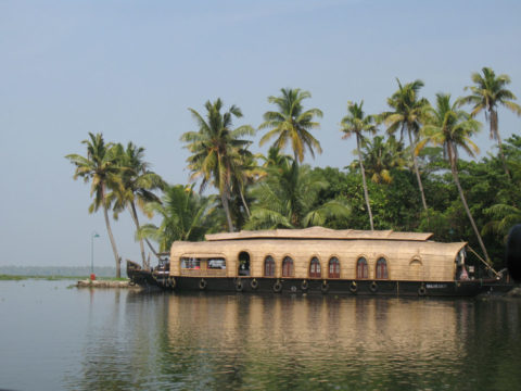
In India, they call the state of Kerala in the country’s far south “God’s own country”. That wasn’t how it felt last August, when monsoon floods devastated its densely-populated low-lying coastal plain. Around 500 people drowned, in an area best known to outsiders for its placid backwaters, where tourists cruise for days across lagoons and down picturesque canals aboard five-star houseboats.
Now the floodwaters have abated, question are being asked about whether the disaster was made worse by water engineering projects in the backwaters that have been designed to feed the state’s population and pamper tourists. Is “God’s own country” damned as well as dammed?
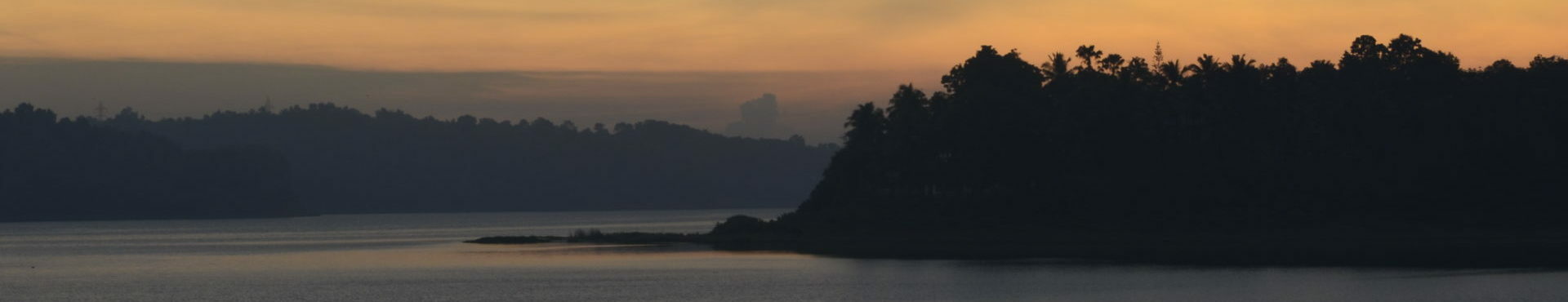
The floods came out of the Western Ghats. The chain of mountains down the west side of India is one of the country’s wettest places, drenched from June to September in monsoon. In early August, the rains there were exceptionally intense and unremitting. The rivers flowing from the mountains west towards the ocean dumped their water into the backwaters on a coastal plain that is often below sea level.
The 100-kilometre long Lake Vembanad, at the heart of the backwaters, rose up across surrounding wetlands and rice paddy, cities and farming villages. A quarter million people took refuge in 1500 relief camps; 10,000 kilometres of roads and 300 square kilometres of farmland were damaged; and Cochin airport was awash.
Four months on, when I visited, the clean-up had been largely completed in many places. Often all that was left was the tide mark on buildings. But in many poor rural communities hardest hit, recovery had barely begun.
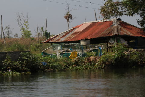
At Kannady, a small village just outside the backwater town of Pullinkunnu in the Kuttanad wetland south of Lake Vembanad, the Red Cross had only arrived in early December to offer tents to people whose houses had been destroyed. I found people still living in broken tin shacks, and a brick house had been entirely destroyed by the floodwaters. Close by, the villagers were laboriously digging a drain across their rice fields to cleanse it of polluted water, so they could plant a new crop.
Some villagers blamed the floods on the backwaters. After all, as Kannady village councillor Ambila Gose pointed out, the floodwaters had come up from the lake and across wetlands into their community. Maybe more drains would keep the water away.
But the truth, say hydrologists, is the opposite. The problem is that many of the backwaters have been drained in the past century. Those that survived had minimised the flood damage by absorbing floodwaters. What the villagers needed was more wetlands, not fewer.
“Out paddy fields used to hold flood water, but they have all been reclaimed,” I was told by B Sreekumar of the Kottayam Nature Society, which is based near Kannady on the Kuttanad wetland. “The flood is man-made. To reduce the flood risks, we should remove all the encroachments.”
The backwaters that dominate the narrow coastal plain of Kerala are a tourists’ delight. Millions come each year, some now to see locations featured in Arundhati Roy’s Booker prize-winning novel The God of Small Things. (Our boatman on Lake Vembanad claimed to have been brought up in the same village as her. It might even be true.)
But the backwaters are not what they once were. Many of the mangroves that once lined Lake Vembanad have been removed to make way for tourist lodges, and to improve their views of the water. Half a century ago, newly independent India rushed to drain the rich wetland soils of the plain for growing rice, as part of a national drive to achieve local food self-sufficiency.
Meanwhile, Dutch engineers brought their techniques of land reclamation to convert parts of Lake Vembanad itself into more than a thousand drained polders, each with stone walls surrounding drained land a metre or more below the level of the lake outside.
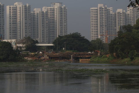
Urbanisation grabbed the wetlands too. In Kochi, the state’s fastest city and main port, a few scraps of mangrove on river banks remind visitors of its wetland past. On the edge of Thrissur, another fast-growing metropolis, real-estate developers have just completed Sobha City, a large estate of apartment blocks, on land annexed from the Kole wetland. It is surrounded by reeds beds swaying in the breeze.
What remains of the Kole wetland is still rich in wildlife. A recent bird survey found 250 species, said local birder, Manoj Karingamadathil. Many of them were at a patch of former paddy near Palakkad, where we saw a greater spotted eagle within seconds of arrival. A pair of hoopoes crossed the path. There were marsh harriers and pelicans feeding on the fish.
Even so much has gone. By the end of the 20th century, the size of Vembanad lake had halved to less than 180 square kilometres. With siltation reducing its depth in many places, the lake’s water holding capacity has diminished by three-quarters. The Kuttanad wetland has declined by two-thirds.
Whatever the ecological losses, engineers had believed they had the complex hydrology of the backwaters under control, with a network of dams and barrages. But that complacency was blown away by the August floods, says Ritesh Kumar, South Asia chief of the environment NGO Wetlands International. The system may be able to handle regular monsoon flows. But it has lost its resilience. In exceptional years, the engineering has primed the state for maximum flooding.
One target of concern target is the dams that barricade many of the rivers flowing from the Western Ghats into the backwaters. In August, even as the floods continued, hydrologists were pointing out that virtually all the dams had their reservoirs full at the start of the floods. They had no room to absorb heavy rains coming downstream.
“Steps could have been taken to avoid the calamities downstream,” hydrologist E.J. James of Karunya University in Coimbatore, a former member of the Kerala Dam Safety Authority, told the Deccan Chronicle at the height of the flooding. “There were predictions about incessant rain and [the] water level was bound to increase.” As soon as the heavy rains were forecast, managers should have begun gradually emptying the reservoirs to create space.
Biswajit Mukhopadhyay, an Indian water engineer working for the US engineering firm IEA, agrees. He told Reuters: “The release could have started earlier, so that… there would have been left-over capacities in the reservoirs to store the water.”
Instead, under instructions to keep their reservoirs as full as possible, managers ended up making rushed releases at the height of the floods, just to save their structures from being broken by the force of water behind them. At the 138-metre high Cheruthoni dam, part of the Idukki dam complex on Kerala’s biggest river, the Periyar, operators opened all five gates, for the first time in 40 years of its operation. “The dams were never meant to be opened like that; it caused massive flooding downstream,” says Kumar. The swollen river gushed downstream and across the Kole wetland, inundating Cochin International Airport for several days. Thousands of people had to be evacuated.
Some civil engineers have questioned how much difference opening the dam gates made. K.P. Sudheer of the Indian Institute of Technology Madras, in Chennai, calculated that emptying the dams earlier on the Periyar river would only have reduced peak discharges downstream by 21 per cent. People in Kannady village question that, remembering clearly that their floods dramatically worsened only after the dam had been opened.
However, the local debate about the dams has diverted attention from a more fundamental issue, says Kumar. This was a once-in-a-hundred-years flood. But this time, when the water was finally released from the overloaded dams, it had nowhere to go. The lakes and wetlands that previously would have absorbed the flood had been dyked and drained to make rice fields, industrial estates, tourist resorts and cities.
“The areas where wetlands reclamation had been most significant were also the ones to bear the severest of the impacts”, said Kumar.
I saw this myself in the village of Pullu, southwest of Thrissur on the River Manakkody. The village is an island surrounded by rice fields created by reclaiming the Kole wetland. Villagers told their story of the floods. How the water came from rivers into their fields and then surged into the village, reaching shoulder high in places. Some residents had to be rescued by helicopter. Many houses were wrecked, and meagre possessions washed away. Villagers lost almost all their livestock, too. “We released the cattle when the flood came, and not many returned,” said villager Siva Dason.
Four months on, they are recovering. They have pumped the polluted floodwaters from their wells. There were government grants for those rebuilding their homes. But first they had to eat. Badirruddin, whose house had been destroyed, was out fishing in the river. And rice fields where they had lost one rice crop to the flood, were already planted with the next.
But the truth was they were in a place that in past times would have been a natural wetland. The Kole wetland is recognised by the Ramsar Convention as an internationally important wetland. Except that, as the woman I met in the village office conceded, her ward was “70 per cent paddy and 30 per cent built on.” There was no wetland, and if there was any Indian law or authority to protect it, she didn’t know about it.
I asked villagers if they thought that converting all the surrounding wetland into rice fields surrounded by dykes might have left them vulnerable when the water came. The village leader K. Parameswaran thought for a while. Perhaps other communities were guilty, he said. It sounded like obfuscation, but it was a fair point. No village can save itself alone. It was a collective failure – a tragedy of the hydrological commons.
The problem lay in attempting to turn large areas of natural wetland and river floodplain into dry land, said Kumar. “This whole coastal area is a floodplain. It is where the water goes; it is natural. We should not try to prevent it.”
–Fred Pearce travelled to Kerela as a guest of Wetlands International. This writing was originally published on Yale Environment 360.