A tool to build a network of sites for migratory waterbirds
The twenty-first floor of the UN Campus’ building in Bonn is about 70 metres above the ground. And from here we could see all the way to southern Africa.
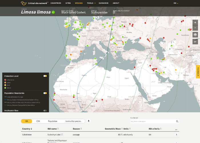
Not by looking out the window, of course, but by looking at a computer screen. We were looking at a web-based map that presents reams of data about waterbirds and the wetlands site they depend on across Africa and Eurasia. It is called the Critical Sites Networks Tool 2.0 (CSN for short), and it is the first stop for anyone dealing with wetlands development or conservation.
You can select a country and find out what waterbirds are found there, and where–or you can
flip that on its head and start with a wetland and see which waterbird populations need it to survive. Having that data laid out as an interactive map helps you plan actions that won’t harm the birds, whether you work in a local planning authority or an international conservation convention.
Indeed it is an international conservation agreement that has driven the creation of the CSN. The Agreement on the Conservation of African-Eurasian Migratory Waterbirds (AEWA) knew that we were the people to ask. We got together a team of staff and partners to pull together information
about the birds and the places they need–all the more important as those places are being made less homely for the birds, by climate change and by some infrastructure that doesn’t take account of enough information.
AEWA is based in Bonn, and that is why we gathered there to speak to its country representatives from across Europe and Africa, along with colleagues from the international agencies that engage with wetlands, climate change, desertification, and government.
I was delighted by the response from those other agencies: we were approached by people who work on desertification, as well as migratory bird experts from countries outside the current project.
This is version 2.0 and for select UN audience in that room, we also previewed the next update. Right now we are using statistics to predict, or model, how the lakes, rivers, and floodplains of Africa and Europe will be affected by climate change. What we are seeing as we work through these models, is that some countries will lose a lot of water—Morocco and Senegal are already jumping out at us. Some areas will gain waterflow. But our experience adds another layer: irrigation and hydropower dams that benefit one area can withdraw the water from other areas and with it, the natural habitats and human livelihoods.
We will launch those updates later in 2018 so keep an eye out for that.
While this tool is designed with scientists, policy-makers, and civil servants in mind, it is open to anyone. I invite you as a nature-lover to look up your favourite waterbird or watering-hole, and admire the huge journeys made by migratory waterbirds. Some of them do indeed see from Bonn to southern Africa, not on a screen, but with their own eyes, as they migrate year-in-year out, as a matter of survival. It is encouraging and rewarding to know that we are doing our bit to keep it that way.
The CSN Tool is part of the Climate Resilient Flyways project. This project is part of the International Climate Initiative (IKI). The German Federal Ministry for the Environment, Nature Conservation and Nuclear Safety (BMU) supports this initiative on the basis of a decision adopted by the German Bundestag.