

Good news for mangroves globally masks big losses in some regions, according to updated Global Mangrove Watch
-
Global Mangrove Watch
-
Update
After decades of anxiety about the fate of the world’s mangroves, the unmatched accuracy of the updated Global Mangrove Watch (GMW) reveals some very welcome news: a net gain of 47,707 hectares of mangrove cover globally over the last 40 years. However, this success conceals losses in some of the world’s most important mangrove countries and raises questions about what is fueling some of the growth.
The GMW 4.1’s enhanced mangrove extent and change maps show that mangrove cover has confounded expectations globally, aligning with recent scientific findings that deforestation and degradation rates are declining, while natural regrowth and restoration efforts are bearing fruit.
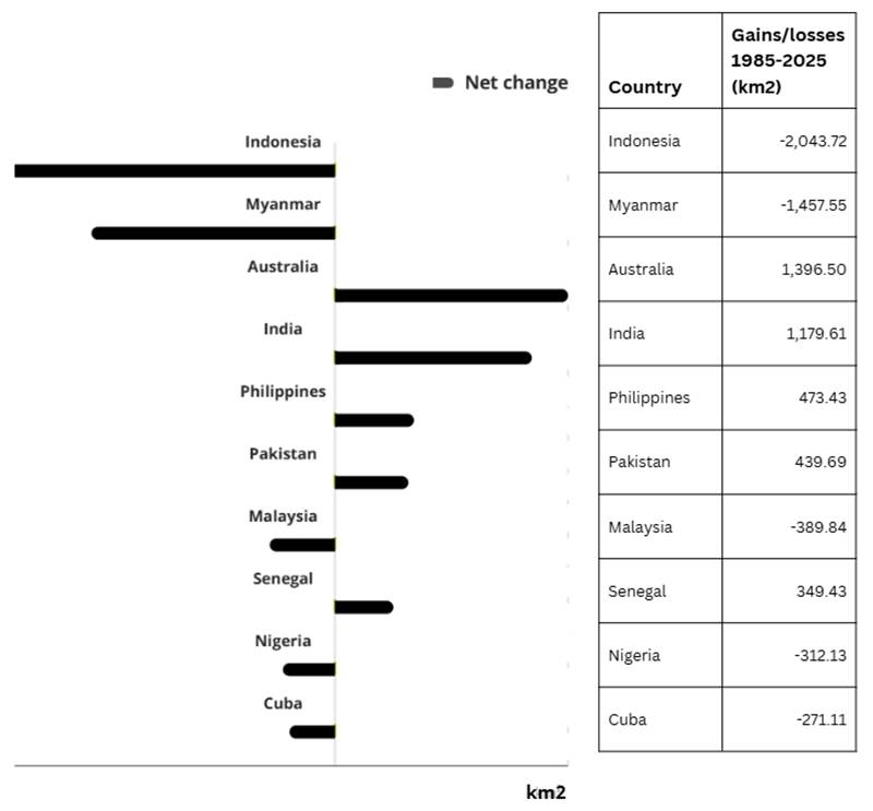
Within this positive global picture, some countries have registered remarkable gains over the last four decades, including India (1,180km2), Philippines (473 km2), Pakistan (439 km2), Senegal (349 km2) and Australia (1,396 km2).
However, the data show that other regions show overall decline in the past 40 years, including Indonesia, which boasts the world’s largest mangrove area, but has lost 2,043 km2 since 1985, Myanmar (1,457 km2), Malaysia (389 km2) and Nigeria (312 km2) driven by a mix of human and climatic factors. Since 2015 however, the extent of mangrove has become more stable in some countries, like in Indonesia.
Safeguarding the remaining 147,283 km2 of mangroves is critical for people, nature, and climate. Thriving mangroves sustain food security and livelihoods, help protect coastal communities and cities from storm surges and sea level rise, sequester carbon at rates up to four times higher than terrestrial forests per hectare, and host rich biodiversity.
Along with natural regrowth, the data shows that increases in the mangrove cover are partly the result of afforestation and restoration efforts. With evidence mounting about the failure of most mass planting projects to establish functional mangrove forests, the GMW will help showcase the benefits of community-based ecological restoration – the best practice approach that restores connectivity, and boosts natural regrowth.
It is also likely that some of the gains, which are predominantly found around rivers and deltas, may be driven by the destructive human activities upstream, such as mining and deforestation, which alter water and sediment flows in the rivers. Ironically, mangrove forests appear to be growing in some areas because other forests are being felled.
The latest update to the free tool also uncovered previously unmapped mangrove areas, including 2 more countries and four more territories – raising the number of mangrove countries and territories to 128. For small island nations, where mangroves are limited but crucial, especially where they connect to adjacent ecosystems, such as coral reefs, these updates provide a much-needed boost for local conservation efforts.
The accuracy of the latest baseline GMW maps is estimated at 93%, a considerable improvement on previous versions, driven by advances in machine learning, higher-resolution satellite imagery, user feedback and other refinements. This enables local practitioners to identify areas where restoration could occur, where conservation should be prioritized, and monitor these sites with greater confidence and precision.
GMW has significantly improved the accuracy of its mangrove extent maps. The new baseline maps, now available until 2025, produced at 10-meter resolution, offer six times the spatial detail of previous versions, making it easier to identify even small features in mangrove areas.Maps tracking mangrove loss and recovery are now available at 30-meter resolution and extend coverage from 1985 to 2025, a substantial expansion from the previous 1996-2020 timeframe.
Lammert Hilarides emphasizes the importance of these improvements: “With our higher resolution maps, field managers and policy makers can detect reductions of mangrove cover at a local scale. For example, with monthly updated mangrove loss alerts, they can investigate the location and cause of mangrove decline quickly and take necessary actions to prevent further losses. Users can now also subscribe and receive deforestation alerts just for their own mangrove area.”
Top 10 gains and losses by country
About the Global Mangrove Watch
The Global Mangrove Watch platform is the evidence base informing the Global Mangrove Alliance and is the result of years of continuous collaboration between local and international scientific, research, environmental organizations, and foundations including Wetlands International, The Nature Conservancy, SoloEO, Aberystwyth University, The Japan Aerospace Exploration Agency, NASA, WWF, the IUCN, and supported by the Oak Foundation, COmON Foundation, GreenChoice, DOB Ecology, and the Dutch Postcode Lottery.